Destination
Madagascar holidaysfrom Nairobi
Baobabs in the west, lemurs in the rainforest, islands off the north-west coast.
Madagascar split from every other landmass at least 60 million years ago, and its wildlife went its own way. UNESCO counts the island among the places with the highest share of species found nowhere else. The lemurs are the famous case: every lemur family on earth lives here and only here.
It is bigger than people expect, too. UNESCO lists it as the world’s fourth-largest island, and it lies about 420 km off the coast of Mozambique. The places you come for are hundreds of kilometres apart, so a trip here means moving. For a first visit we would pick three pieces: rainforest and lemurs in the east, the baobabs or the Tsingy in the west, and a few beach days in the north-west to finish.
Malagasy and French are the official languages, and Antananarivo is the capital. The island keeps Nairobi time, so there is no jet lag. The long legs are flown: the tourism board says Madagascar has one of the densest domestic flight networks in the world.
Where you’ll go
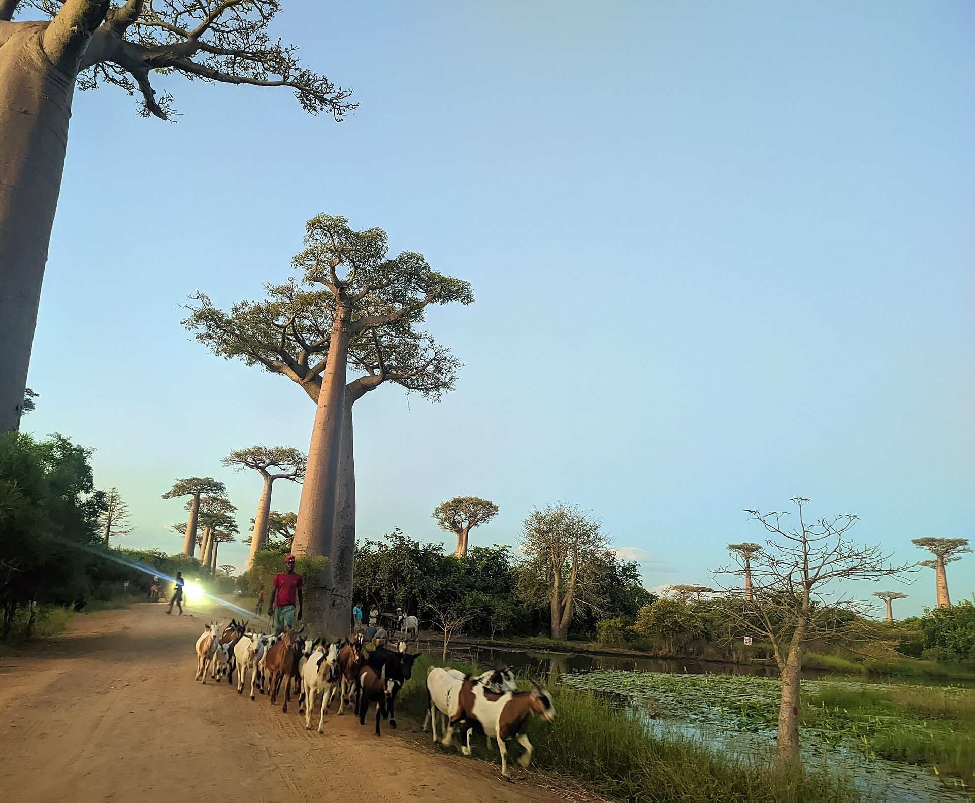
The Avenue of the Baobabs. On the west coast, on the road from Morondava to Belo-sur-Tsiribihina, the baobabs stand over the track and the flat country around it. The tourism board says the avenue is at its best at sunrise and sunset, when the light runs low along the trunks. That is when you want to be there.
Andasibe. The rainforest parks here are 140 km east of Antananarivo along the RN2, close enough to the capital to make a good first stop. This is indri country. Madagascar’s largest lemur is seen here every day, and the parks authority says there is no real dry season in this forest: it stays green all year.
The Tsingy de Bemaraha. UNESCO calls it a “forest of sharp stones”: limestone pinnacles up to 100 metres high, on the World Heritage List since 1990. The park lies about 600 km from Antananarivo in the centre-west of the island, which makes it a journey of its own.
Isalo. Down the RN7 towards Toliara, 701 km of paved road bring you from the capital to Ranohira, the park’s gateway town. Isalo is canyons and natural pools. The evening ends at the Isalo window, a hole in the rock that frames the sunset. The park is open all year, and you go in with a local guide.
Ranomafana. The park takes its name from a village known for its hot springs, 7 km away. It holds 14 species of lemur, four of them critically endangered, and it is one of the parks UNESCO listed in 2007 as the Rainforests of the Atsinanana.
Nosy Be. The “island of perfumes” lies off the north-west coast, with flights from Antananarivo into Fascene airport. It is where the beach days go at the end of a trip. Lokobe National Park covers 862 hectares of the island.
Île Sainte-Marie. Off the east coast, Sainte-Marie, also called Nosy Boraha, is known for its beaches. From June to September humpback whales come in along this coast to mate and give birth; the timing shifts a little from year to year.
Antananarivo. The capital’s Upper Town is on UNESCO’s Tentative List. The Royal Hill of Ambohimanga, a World Heritage site since 2001, is the cultural excursion from the city.
When to go
Madagascar’s national tourism office puts the dry season at April to October and the rainy season at November to March, and names April to June and September to October as the ideal months to go. July and August are dry too, and fall in the whale season off Sainte-Marie, which runs from June into September. November to April is cyclone season, when the coast is most exposed, and some national parks cannot be reached in the rains from January to March. The parks authority names May to October as the best time for Mantadia, beside Andasibe, and April to November for Ranomafana, ideally in the mornings.
The rains matter on the road too. From December to April many secondary roads can only be driven by four-wheel drive, and bridges wash out. It is one more reason we would choose the dry months.
Flights from Nairobi
Kenya Airways sells Nairobi to Antananarivo on its own flight, KQ262. Ethiopian connects through Addis Ababa, and Airlink through Johannesburg. Madagascar Airlines does not fly to Nairobi.
We ticket the domestic flights with the international one and fix them first, because their schedule decides the route.
Practical notes
- Kenyan passport holders need a visa. Madagascar’s tourist eVisa is open to every nationality: single entry, for up to 60 days. Apply online through the official portal, evisamada.gov.mg, or get it on arrival at the eVisa counters; the fee is the same either way. Stays can be extended to 90 days at the immigration office. We checked this in September 2026.
- Arriving from Kenya, you need a yellow fever vaccination certificate if you are nine months or older. The rule also covers a transit of more than 12 hours at an airport in a country with yellow fever risk.
- Everyone fills in a health declaration on arrival and goes through health screening. In September 2026, anyone who had been in, or passed through, a country affected by Ebola in the previous 21 days could be refused entry, and Uganda was among those countries. If Madagascar comes after a gorilla trek in Uganda, tell us early.
- Don’t pack any food, fruit included. Bringing it in is illegal.
- Tap water is unsafe. Drink boiled or bottled water and skip the ice.
- Theft is common. There have been violent robberies on isolated beaches, even in daylight, and armed robberies on main roads at night. We plan road days to finish before dark.
- Local taboos, called fady, govern parts of daily life and change from region to region. Ask your guide what applies where you are.
- Entry requirements are confirmed for your passport before anything is held.
At a glance
Practical facts
- Plug & voltage
- C/D/E/J/K
- 220V · 50Hz
- Currency
- MGA
- Malagasy ariary
- Time zone
- UTC+3
- (EAT), no DST, same as Nairobi
- Driving side
- Right
- Languages
- Malagasy
- French
- SIM & data
- A TravelNet eSIM, live on landing. Or a Yas (formerly Telma), Orange or Airtel SIM in Antananarivo with your passport. Signal thins out quickly away from the towns and the main roads.
- Tipping
- Appreciated and increasingly expected in tourism. Guides, drivers and the porters on a forest walk are looked after at the end, in ariary and in small notes. Ask us what feels right for your route before you go.
- Tap water
- Unsafe. Drink only boiled or bottled water, and skip the ice.
Comparing countries? The full table puts every destination we plan side by side, and when to go does the same for the months.
Getting there
The flights for this trip are ticketed at the same desk as the rest of it: Ethiopian Airlines and Kenya Airways among the 66 airlines we ticket. Ask for the fare when you ask for the trip, and one person holds both.
Why go
Madagascar in six lines
- The Avenue of the Baobabs outside Morondava, at sunrise or sunset
- The indri at Andasibe, the largest lemur, 140 km east of Antananarivo
- The Tsingy de Bemaraha, limestone pinnacles up to 100 metres high
- Isalo's canyons and natural pools, down the RN7
- Nosy Be and the islands off the north-west coast
- Humpback whales off Île Sainte-Marie from June to September
Privately crafted
There's no set itinerary here
Every Madagascar journey we plan is built from scratch: your dates, your pace, your route. Tell a travel designer what you have in mind.
Talk to a travel designerQuestions we are actually asked
Do Kenyans need a visa for Madagascar?
How do you fly from Nairobi to Madagascar?
When is the best time to visit Madagascar?
Do I need a yellow fever certificate for Madagascar?
What currency does Madagascar use?
Is Madagascar safe for travellers?
Plan your Madagascar journey
One travel designer, one WhatsApp thread, start to finish. We answer within one working day.